


On April 8, 2024, Americans in every state will have the chance to witness either a partial or total solar eclipse. Solar eclipses materialize when the moon passes between the earth and the sun, casting a shadow on the earth’s surface and partially or fully obstructing the sun from view.
Despite the relative frequency of solar eclipses, occurring approximately two to four times a year, the geographic path of totality—the region where viewers can experience the complete blockage of the sun—is small. Consequently, for individuals in any given location, the opportunity to observe a total solar eclipse is an extremely rare event. NASA notes that, on average, this phenomenon occurs roughly once every hundred years. However, some regions may experience total solar eclipses more frequently.
For instance, the most recent total solar eclipse visible in the U.S. took place in 2017, with the path of totality extending from Oregon to South Carolina. Prior to 2017, only two solar eclipses in the 20th century had totality paths that overlapped some portion of the United States. Looking ahead, the next coast-to-coast total solar eclipse won’t occur until 2045.
The 2024 Solar Eclipse Path of Totality
The April 8th solar eclipse path of totality stretches from Texas to Maine
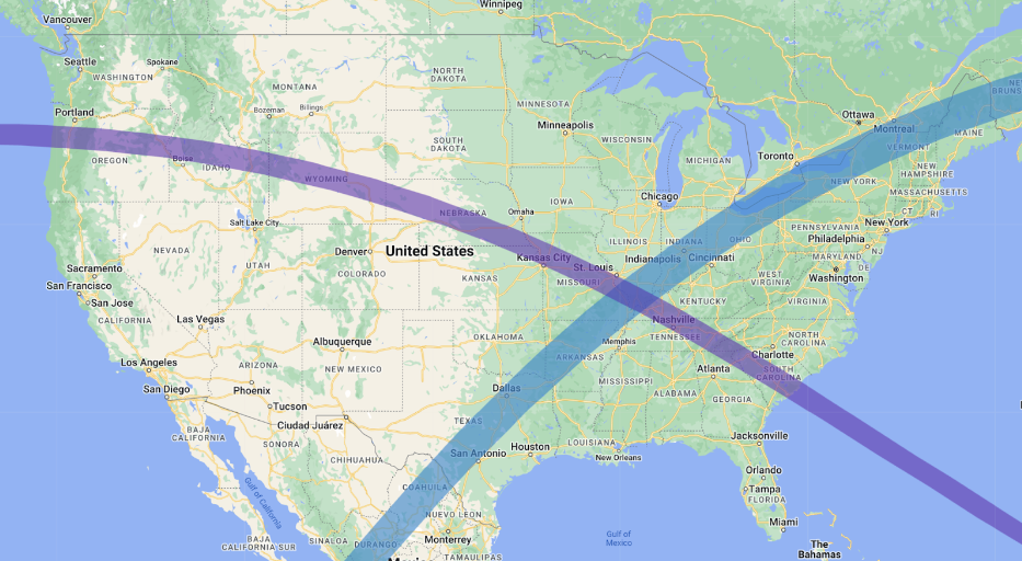
Source: Captain Experiences analysis of NASA data shown on Google Maps. The 2024 totality path is shown in blue; the 2017 totality path is shown in purple.
Compared to the 2017 total solar eclipse, the upcoming 2024 event will boast a wider and more populated path of totality. While the totality path in 2017 averaged 60–70 miles in width, the 2024 eclipse will span approximately 110–120 miles.
Moreover, the path of totality for the 2024 eclipse encompasses a greater number of major U.S. cities compared to that of 2017—notably, several large cities in Texas. As a result, an estimated 31 million Americans will find themselves within the path of totality for the 2024 event, substantially more than the 12 million in 2017. Residents in 15 states—Texas, Oklahoma, Arkansas, Missouri, Tennessee, Illinois, Kentucky, Indiana, Ohio, Michigan, Pennsylvania, New York, Vermont, New Hampshire, and Maine—will have the opportunity to witness the moon completely blocking the sun’s view in 2024.
Largest U.S. Cities in the 2024 Solar Eclipse Totality Path
Texas is home to the top 4 largest cities in the path of totality
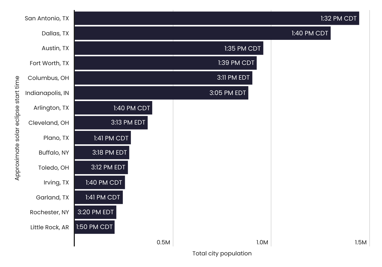
Captain Experiences analysis of NASA and Census data
Due to the unique path of the 2024 eclipse, Texas stands out as the state hosting the top four largest cities within the totality path and eight of the top 15. Notably, among the five largest cities in Texas—Houston, San Antonio, Dallas, and Austin—only Houston will not experience the total solar eclipse this year. Similarly, in Ohio, three out of its top four cities fall within the 2024 path of totality, including Columbus, Cleveland, and Toledo. Other major U.S. cities within the totality path are Indianapolis, IN, Buffalo, NY, Rochester, NY, and Little Rock, AR.
Another unique characteristic of the 2024 eclipse is that several large U.S. cities lie in close proximity to, though not directly within, the totality path. Residents in these cities will still have the opportunity to witness a nearly total eclipse. For instance, individuals in Memphis, TN, St. Louis, MO, Louisville, KY, Cincinnati, OH, and Pittsburgh, PA can all expect to experience at least a 95% partial eclipse.
Population Living in the Path of Totality by State
While Texas has the most residents overall living in the path of totality, Ohio has the highest proportion
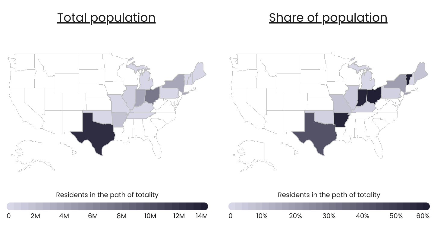
Captain Experiences analysis of NASA and Census data
In terms of total population within the path of totality, Texas leads with 12.6 million residents, followed by Ohio (7.1 million), Indiana (3.9 million), and New York (3.6 million). However, when considering the states with the highest proportion of residents within the totality path, Ohio, Vermont, Arkansas, and Indiana are this year’s frontrunners. In each of these four states, more than 57% of the population resides in areas where the total eclipse will be visible.
Conversely, only tiny slivers of Michigan and Tennessee fall within the totality path. Fewer than 10,000 residents in Michigan and fewer than 1,000 residents in Tennessee are estimated to live in areas where the total eclipse can be observed.
For Americans living outside of these areas, the April 8th event will still be worth watching—albeit using eclipse safety glasses the entire time. With the exception of Florida, most East Coast residents will be able to observe a partial eclipse with 70%–90% obscuration. Maximum obscuration in Florida ranges from approximately 45%–75%. West of the totality path, obscuration will decrease the further west and north one lives. On the West Coast, maximum obscuration ranges from around 55% in San Diego to 20% in Seattle.
This study was conducted by Captain Experiences. For details about how the analysis was conducted, see the methodology section below.
Methodology

Photo Credit: kdshutterman / Shutterstock
To determine the states with the most people living in the path of totality for the 2024 solar eclipse, researchers—using data from NASA’s Scientific Visualization Studio and from the U.S. Census Bureau’s 2020 TIGER/Line Shapefiles and 2022 American Community Survey 5-Year Estimates—identified the Census tracts in each state that overlap fully or partially with the totality path. Populations for the resulting Census tracts were summed and divided by the state total population. For Census tracts that only partially overlap, populations were reduced based on the percentage of the Census tract’s area outside of the totality path.
To identify the largest places (cities, villages, boroughs, etc.) that fall within the path of totality, researchers identified the Census places that overlap fully or partially with the totality path. Only places with a 10% or more overlap with the totality path were included. Additionally, places with fewer than 1,000 people were filtered out. The approximate start time for each place was calculated by merging the Census places shapefiles with NASA’s umbra 10-second interval shapefiles, and selecting the earliest time that intersected with each place. Times were converted to Central Daylight Time or Eastern Daylight Time depending on the location.
For complete results, see Mapping the 2024 Total Solar Eclipse: States With the Best View on Captain Experiences.